
A new algorithm that generates smooth 3-D images of underground fault locations makes it easier to find petroleum resources.
© 2016 KAUST
The deep cracking faults that lie within the Earth’s crust are significant geologic surfaces for oil exploration and earthquake prediction. A team from KAUST developed an algorithm that smoothly detects faults and other three-dimensional (3-D) surfaces with high computational efficiency even amid noisy and cluttered data sets [1].
Identifying objects in images using geometric curves is critical to many computer vision applications. One method uses fast marching algorithms that track how interfaces evolve with time from an initial seed point. This technique uses efficient computational routines to expand the seed curve step-by-step until mathematical conditions corresponding to a boundary are met—the steep slope of a cliff, for instance.
Requiring software users to define probable surface boundaries, however, makes it tricky to use fast marching algorithms for complex 3-D problems.
“It’s a challenge to extract a surface from an image volume when the boundary is non-empty and unknown,” explained Ganesh Sundaramoorthi from the University’s Computer, Electrical and Mathematical Science and Engineering Division. “Until now, no algorithm could handle this task.”
Sundaramoorthi and colleague Marei Algarni recently developed software known as SurfCut to solve these issues. The pair realized that for two-dimensional (2-D) objects, a small curve from a seed point can trace out the surface and automatically stop along the boundary. However, performing the equivalent operations in 3-D required a new approach based on topology, or the mathematical descriptions of features that are preserved under deformation.
The new analysis program uses fast marching methods to compute the shortest paths between a seed point and a moving interface. Ridge sets are then computed by retracting the interface until rigid topological features emerge. These features are likely to lie on the surface, and the team’s algorithm extracts them to efficiently determine 3-D surfaces.
“Our idea embeds 3-D curves on the surface as ridges of a moving front, and we watch the curves evolve as the front propagates,” noted Sundaramoorthi. “Ridge sets are difficult to extract from realistic images, which are discrete and noisy, but our algorithm makes this operation feasible.”
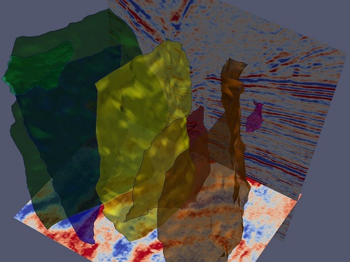
To demonstrate the usefulness of SurfCut, the researchers analyzed a series of seismic images and generated new underground 3-D maps with stunning clarity. “Understanding complex fault surfaces can be hard, even for expert geologists,” Sundaramoorthi said. “Our technique allows them to see structures that are impossible to view using 2-D slices, and is really robust against data imperfections. This could directly impact the oil industry.”