A major challenge to mobilizing action on climate change is the overwhelming scale and complexity of the threat. For many people, it’s just too much information to absorb.
The effects of climate change are global, and are caused by a staggering array of factors. Although some of these effects are already being felt, others are predicted to begin only long decades in the future. And while scientists generally agree on the inevitability and the seriousness of the threat, many members of the public — and, significantly, some politicians — remain sceptical.
How can scientists and campaigners convince policymakers of the danger and persuade them to act? And, once persuaded, how can governments decide where they should allocate their limited adaptation resources?
In Southeast Asia, one response has been to produce an image — a map — that serves as a snapshot of the risks from climate change effects for each and every corner of the region.
Aspects of vulnerability: how the map was made
The project is led by the Economy and Environment Program for Southeast Asia (EEPSEA), based in Singapore. EEPSEA was established in 1993 to support research and training in environmental and resource economics in nine countries. Canada’s International Development Research Centre, the Canadian International Development Agency, and the Swedish International Development Cooperation Agency fund the program.
The mapmakers focused on 592 sub-national provinces or districts in Vietnam, Laos, Cambodia, Thailand, Malaysia, the Philippines, and Indonesia. Guided by an assessment framework developed by the United Nations’ Intergovernmental Panel on Climate Change, they designed three preliminary maps, each illustrating a different category of climate-related information:
* Exposure is the risk, based on the historical record, of extreme events such as tropical cyclones, floods, landslides, droughts, and sea level rise.
* Sensitivity has two components. Human sensitivity is directly related to population density; that is, the more people who live in a region, the more vulnerable it will be to climate change. Ecological sensitivity is directly related to biodiversity, measured by the percentage of protected areas in the region.
* Adaptive capacity is a measure of local human resilience, and is a function of socio-economic factors such as income, literacy, life expectancy, poverty, and inequality, as well as of technology and infrastructure.
Red equals risk: hot spots exposed
When all three maps are superimposed, the overall index vividly highlights — in hot crimson — the most vulnerable places in Southeast Asia. These are: all the regions of the Philippines, the Mekong River Delta in Vietnam, almost all the regions of Cambodia, North and East Lao PDR, the Bangkok region of Thailand, and Indonesia’s West Sumatra, South Sumatra, West Java, and East Java.
Little of this will surprise climate change activists, but the map does suggest one crucial new finding: the significance of adaptive capacity. For example, although most regions of Cambodia are seldom exposed to climate hazards, they are vulnerable because of their low adaptive capacity. On the other hand, the high adaptive capacity of eastern Vietnam — which is susceptible to cyclones — has moderated its vulnerability.
Some places with high adaptive capacity nonetheless remain at high risk. In all of Southeast Asia the district most vulnerable to the effects of climate change is Central Jakarta.
Even though this area can draw on significant economic resources and has much modern infrastructure, it is densely populated and has been exposed to all the extreme climaterelated events, except cyclones.
Positive response: a call for action
Despite being a relatively small and simple initiative, the map has generated lots of buzz since it was unveiled in early 2009. Launch events were held in Manila and Jakarta — places where people might be expected to challenge the message. Instead, the various workshops and forums drew receptive audiences, not only of researchers and activists but also of senior policymakers.
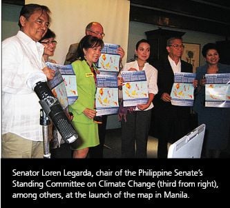
Some politicians responded immediately and positively. In Manila, for example, Senator Loren Legarda, who is chair of the Senate’s Standing Committee on Climate Change, waved the map and said grimly, there is no reason to smile, because Philippines is all red.” Senator Legarda has indicated that she may run for president at the next elections. In Jakarta, Mayor Sylviana Murni — citing the EEPSEA study — ordered the immediate planting of more ornamental evergreens to help curb pollution.
In both the Philippines and in Indonesia, the story has been covered widely on radio — notably by one station, DZRH-AM, that reaches 2 million listeners worldwide — television, the mainstream print media, and the Internet, including many blog sites. The story has been picked up internationally, by Reuters, the BBC, and UN-TV, among others.
Another launch event was held in Phnom Penh, Cambodia, in September 2009. It was attended by HE Thuk Kroenvutha, Secretary of State, Ministry of Environment and about 150 participants.
Next steps: more research, local maps
EEPSEA plans to update the map by taking account of new information and to refine it by using different assumptions and scenarios.
Meanwhile EEPSEA proposes to help selected local governments apply some of the study’s recommendations to their own situations. In particular, it will train them to conduct their own economic research and vulnerability assessments, and to create their own local maps. The goal is to empower communities by providing them with the tools to inform, educate, and build understanding of the effects of climate change.
Another new activity is a research program in five countries — China, Philippines, Thailand, Indonesia, and Vietnam — to better understand what determines the adaptive capacity of different groups of people in dealing with climate change.
This research will analyze the adaptation behaviour of households, communities, and local government when confronted with major climate-related disasters, such as extreme typhoons and flooding, and the reasons for the adaptation choices that they make.


