
Remote Sensing
About Remote Sensing
Remote Sensing is an international, peer-reviewed, open access journal about the science and application of remote sensing technology, and is published semimonthly online by MDPI.
News

29 Oct 2021
Institute of Industrial Science, The University of Tokyo (UTokyo-IIS)
Researchers from The University of Tokyo Institute of Industrial Science find that drones may be the next generation of communication bases to monitor the ocean and seafloor because of their high-speed positioning, stability, and efficiency.

16 Apr 2021
Tohoku University
Rapid and accurate flood mapping following a disaster is crucial for accelerating relief and response decisions. With news crews often the first on the scene, Tohoku University researchers have created a machine learning model that harnesses the power of media photos. The model helps quickly identify flooded buildings within 24 hours of the disaster.
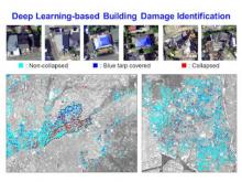
01 Oct 2020
Hiroshima University
Researchers trained an AI to assess post-disaster building damage just by looking at aerial images of the aftermath.
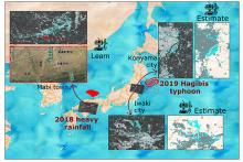
16 Jul 2020
Tohoku University
The past is often the window to our future, especially when it comes to natural disasters. Using data from the 2018 floods that struck southwestern Japan to calibrate a machine learning model, researchers from the International Research Institute of Disaster Science (IRIDeS) at Tohoku University and the Japan-Peru Center for Earthquake Engineering Research and Disaster Mitigation (CISMID, in Spanish), have successfully identified the flooding caused by Typhoon Hagibis.