

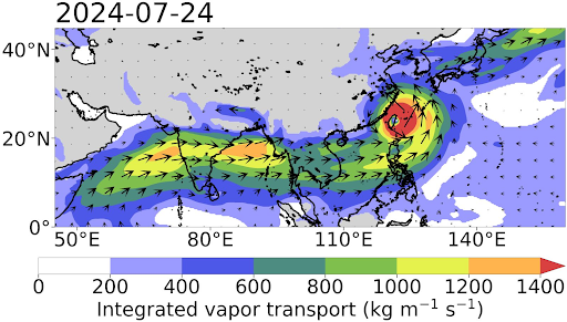
A snapshot of the moisture conveyor belt (MCB) in action during the July 2024 Habagat event, enhanced by Super Typhoon Gaemi (local name: Carina). The image shows an elongated corridor of enhanced moisture transport extending from the Arabian Sea across Southeast Asia to the Philippine Sea.
Weather scientists have long known that typhoons even hundreds of kilometers away from the Philippines can interact with the southwest monsoon, resulting in days-long heavy rains. But the exact dynamics of this relationship have remained largely unknown until recently.
A new study spearheaded by the Ateneo de Manila University VORTEX Research Lab and the Manila Observatory together with PAGASA and Tokyo Metropolitan University sheds light on this complex phenomenon—and may even pave the way for accurately forecasting heavy monsoon rains up to several days in advance.
Every year, the southwest monsoon—locally known as Habagat —brings rain across the western parts of the Philippines. Many welcome the first showers with relief after months of intense heat. But the monsoon has also been known to bring relentless downpours that produce flooding.
Analysis of over four decades of extreme Habagat events has revealed that the country’s heaviest southwest monsoon rains are driven not by a single weather event but by a combination of atmospheric conditions that come together across thousands of kilometers.
The researchers analyzed 53 cases of extreme Habagat rainfall linked to tropical cyclones between 1981 and 2023. Rather than examining each event individually, they looked for weather patterns that appeared repeatedly across different cases.
They identified a recurring setup: a strengthened Habagat ; a tropical cyclone northeast of the Philippines; and other atmospheric conditions that allowed large amounts of moisture to flow toward the country. Together, these factors form what is known as the “moisture conveyor belt” (MCB) that transports water vapor from the Indian Ocean across Southeast Asia to the Philippines. When these conditions are in place, they often lead to prolonged periods of intense rainfall.
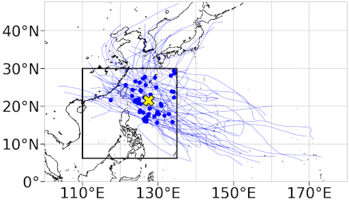
This map tracks the tropical cyclones associated with the 53 extreme Habagat rainfall events analyzed in the study. Most of the storms are positioned northeast of the Philippines rather than directly over the country, helping strengthen the southwest monsoon and draw moisture toward western Luzon.
The researchers found that the buildup to these severe rainfall events takes several days. As the Habagat strengthens over the northern Indian Ocean, it helps establish the MCB that repeatedly, in many of the cases analyzed, indicates that the country’s most severe southwest monsoon events follow a common pattern rather than occur purely by chance.
Beyond explaining how extreme Habagat events develop, the findings could help scientists better recognize the atmospheric conditions that favor these episodes. The researchers also found that existing operational weather forecasts capture many of these large-scale patterns, providing a foundation for further improving predictions of high-impact southwest monsoon events.
Alwin Andriel L. Bathan, Lyndon Mark P. Olaguera, Faye Abigail T. Cruz, Jose Ramon T. Villarin, John A. Manalo, and Jun Matsumoto published their research, Synoptic conditions favoring tropical cyclone-enhanced southwest monsoon high precipitation events in the Philippines , in the July 2026 issue of the journal, Atmospheric Research . — Danika Geronimo, Ateneo Research Communications
SOURCE: https://archium.ateneo.edu/manila-observatory/28/
For interview requests, please email Ateneo VORTEX Research Lab head Dr. Lyndon Mark P. Olaguera at [email protected] .
For other inquiries, please email [email protected] . Visit archium.ateneo.edu for more information about our latest research and innovations.