


Bringing together expertise in geography, atmospheric sciences and civil engineering, a National Taiwan University team has discovered that invisible “rivers in the sky” form drainage systems much like rivers on land. Their new method identifies the critical upwind areas that sustain rainfall, offering a new perspective on land and water management.
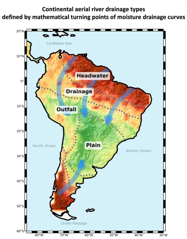
The hydrological structure of aerial rivers (flying rivers) can be classified into four types: headwater, drainage, outfall, and plain regions.
National Taiwan University
Water does not flow only through rivers on the ground. Vast quantities of water also move through the atmosphere, carried by winds from oceans and land before eventually falling as precipitation hundreds or even thousands of kilometres away. These persistent pathways of atmospheric moisture are often referred to as “aerial rivers” or “flying rivers.”
A research team led by National Taiwan University (NTU) has shown that these invisible rivers form organized drainage systems with structures that resemble terrestrial river networks. By analysing long-term atmospheric moisture transport across South America, the researchers identified four distinct hydrological regions within the continental aerial-river system: headwater, drainage, outfall, and plain regions. The study is published in Nature Communications.
A major challenge in managing aerial rivers is determining how far upstream—or, in atmospheric terms, how far upwind—management efforts should extend. Moisture reaching a given region may originate across vast areas, but not all source regions contribute equally. Previous studies have often relied on fixed thresholds to define important source areas, making results sensitive to the threshold selected.
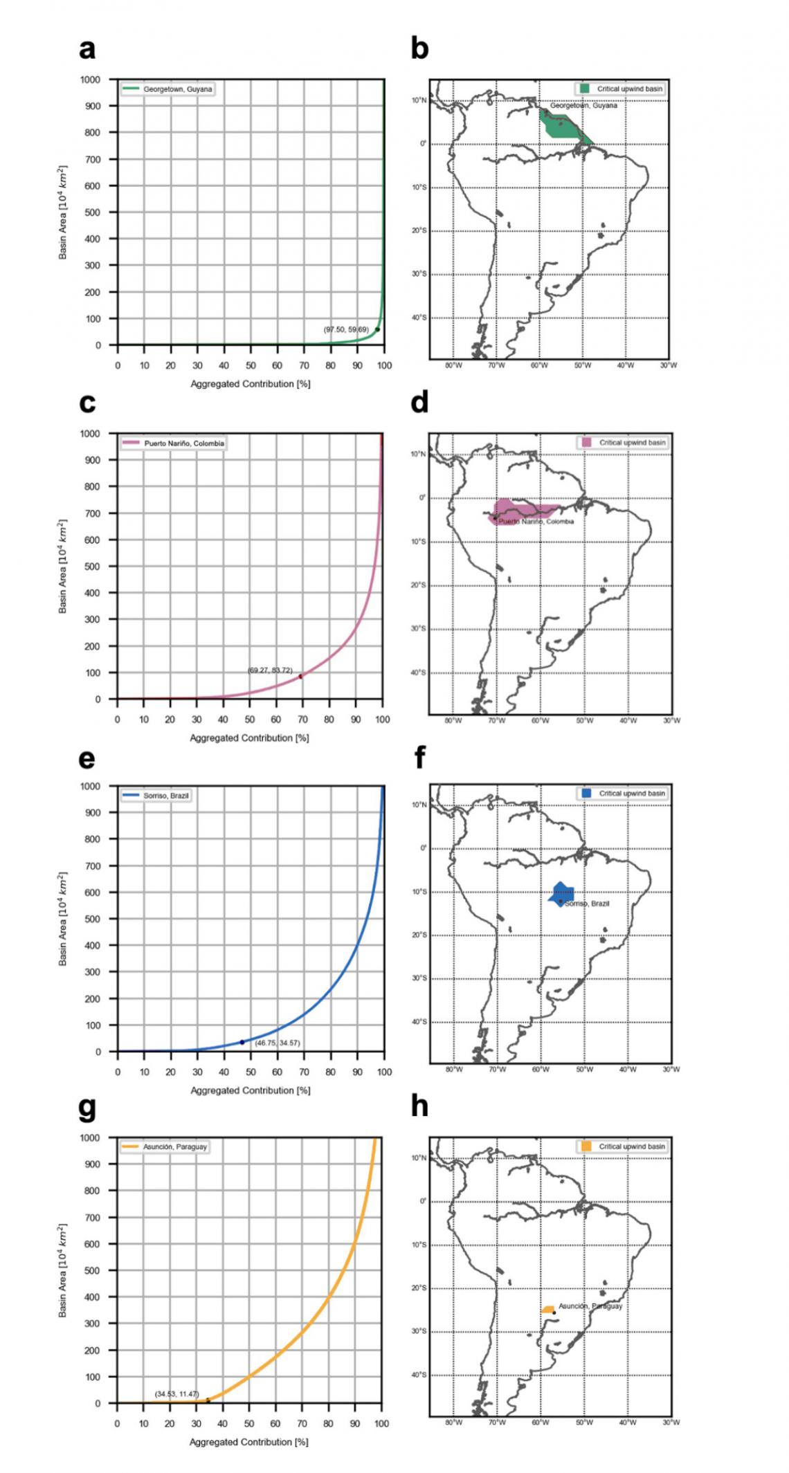
To address this problem, the team developed a mathematical approach for identifying a natural turning point in the relationship between the size of an upwind source area and the amount of moisture it contributes. This turning point defines a critical upwind basin, beyond which the additional land area contributes progressively less efficiently to rainfall in the target region. The results show that the location of this turning point varies substantially across South America, demonstrating that no single threshold can adequately characterize all aerial-river systems.
The findings provide a new way to think about water-resource management. Conventional approaches generally follow surface watersheds or administrative boundaries, but aerial rivers cross both. Land-use change in one region can therefore influence rainfall and water availability far downwind.
Example cases illustrating the identification of critical upwind basins. Panels a, c, e, and g show moisture drainage curves and their turning points for selected regions—Georgetown, Puerto Nariño, Sorriso, and Asunción, respectively. Panels b, d, f, and h present the corresponding maps of the critical upwind basins for each region.
National Taiwan University
“Our earlier research showed that land-use change can affect water availability far downwind through flying rivers. What was still missing was an objective way to identify which upwind areas matter most. The turning-point approach provides a systematic method for defining these critical source regions and for exploring the factors that govern moisture drainage. By doing so, it brings the concept of aerial rivers closer to practical application in water-resource management,” says first and co-corresponding author Prof. Wei Weng of NTU Department of Geography.
“These patterns emerge from the accumulated behaviour of atmospheric moisture over long timescales. As moisture moves across the continent, changes in transport and recycling processes generate distinct regions within the aerial river system. Understanding the atmospheric mechanisms behind these patterns helps explain why different regions depend on their upwind moisture sources in fundamentally different ways,” says Prof. Kai-Chih Tseng of NTU Department of Atmospheric Sciences and the study's co-corresponding author.
“Atmospheric moisture transport involves an enormous amount of spatial and temporal information. By combining large-scale data processing with statistical analysis, we can uncover systematic patterns within this complexity and, importantly, translate them into quantitative criteria that can be compared across regions,” says Prof. Li-Pen Wang of NTU Department of Civil Engineering and co-corresponding author of the study.
The team is now extending the approach beyond South America and developing a global dataset of aerial river drainage systems. The next step is to investigate how these atmospheric connections vary across the world—and what they could mean for water-resource management on a global scale.
Prof. Wei Weng‘s email address: [email protected]
Prof. Kai-Chih Tseng‘s email address: [email protected]
Prof. Li-Pen Wang‘s email address: [email protected]
Advertisement