
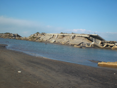
Collapsed sea embankment in Isobe, Soma City
Written by: Tomoya Shibayama, Professor, Faculty of Science and Engineering, Waseda University
<Before reproducing in any form, please read the copyright notice at the end of this article>
(1) Flyover inspection and field survey
Every stricken area I saw from the air on March 19 was covered with mud and had turned grey. Eight days had passed since the tsunamis had hit, and the extent of the damage became increasingly evident. As many of the scattered fishing villages on the Sanriku coast were affected by catastrophic damage, however, it was still difficult then to grasp the whole picture. Through the investigations of tsunami height and the extent of the damage that I conducted on March 15 and 16 in Ibaraki and Chiba, from March 25 to 28 in Miyagi and Fukushima, and April 4 and 5 in Iwate, I became deeply aware of the serious damage brought by these tsunamis.
These tsunamis breached levees, the last fort to protect human lives when tsunamis hit, in various locations, and they overwhelmed even intact levees and hit communities. In the town of Taro, the tsunami passed a few meters above a ten-meter-high levee, and devastated the community behind. In the Tanohama area along Funakoshi Bay, in the town of Yamada, a seven-meter-high levee crumbled in some places, and approximately 80% of the community, except houses along the hill, was engulfed by the tsunami. Even the tsunami breakwaters at the mouth of the bay that were constructed as an ace to protect the entire part of the jagged bay, which is a characteristic of a ria coastline, toppled at the mouth of Kamaishi Bay as if the teeth of a comb were missing, and almost crumbled and submerged in seawater at the mouth of Ofunato Bay.
In addition, a characteristic of this disaster is that the coastal areas in Sendai City, and the coastal plains in Natori City, Soma City, and Minamisoma City were hit by tsunamis other than the tsunami-wary Sanriku coast. Many lands around the mouth of the Natori River were covered with seawater.
(2) Views on inspection results
Generally, when a big tsunami of more than 10 meters high hits, levees and buildings face dozens of tons of immense wave pressure per square meter, and are hit and impacted by flotsam from ships and the like. In this disaster, some areas were hit by an earthquake of level seven magnitude—on the Japanese seismic scale—and strong tremors, and therefore I cannot deny the possibility that structures had been damaged before the tsunamis hit. I have surveyed all the recent tsunamis and storm surges, including the massive Indian Ocean tsunami (2004), storm surges caused by Cyclone Nargis in Myanmar (2008), and the tsunami in Chile (2010) that caused extensive damage. However, I have never seen anything like these tsunamis that destroyed so many structures along the Sanriku coast, other than the massive Indian Ocean tsunami in Aceh, Indonesia.
Also, similar cases of disasters further inland caused by flooding tsunamis in low-lying flatlands observed in the coastal areas in Sendai City, around the mouth of the Natori River, and Soma City were seen in the areas affected by storm surges in Myanmar and Bangladesh where low-lying flatlands spread out along the coastline. However, this is the first time since the 1946 Nankai earthquake in Japan. Lessons learned from the tsunamis on low-lying flatlands are important in considering countermeasures against future tsunamis triggered by the Tonankai earthquake.
(3) Assumption of conventional disaster prevention plans
Conventional tsunami prevention plans were developed with the idea that preparations are made to protect the lives and property of residents, based on the biggest tsunami in history and the possible scale of tsunamis generated by future earthquakes. Because the Sanriku coast had been struck by many tsunamis including the Meiji Sanriku tsunami in 1896, and many records of the tsunami disasters had been preserved, it was considered an area with the most advanced tsunami countermeasures in the world. However, these tsunamis surpassed by far the assumed scale, wreaking enormous damage.
(4) Issues in developing future disaster prevention plans
Changes in land use and relocations of houses to relatively high-lying land should be considered, in view of long-lasting sustainability for local communities in affected areas. In Ulutogia on Apia Island, in the Independent State of Samoa that was struck by a tsunami in September 2009, residents made their matai (chief)-led decisions to move to high-lying land from their seaside villages at the community level in approximately one month after the disaster, and promoted relocation and construction of their new villages on the hill. Because the adjustment of rights is difficult in Japan, national and prefectural governments need to take initiative in planning relocations.
One urgent issue that must be tackled immediately at the national level is recasting disaster prevention plans around the country, such as reviewing the assumed scale of tsunamis in developing disaster prevention measures, and mapping out evacuation plans in advance without being bound by predicted values, which could respond to tsunamis that exceed these values hitting.
Specifically, all prefectural governments should reexamine existing tsunami hazard maps and review prefectural disaster prevention plans. They will need to focus on any earthquakes considered less likely to occur and not included in the existing plans, modify wave source models of the predictive tsunami simulation, and raise the predicted height of arriving tsunamis. This means that it is necessary to enhance physical countermeasures that require raising existing protective structures such as tsunami levees.
Because these tsunamis revealed that residential areas could not be protected by protective structures alone, non-physical countermeasures should be implemented immediately as well, which involves the revision of evacuation plans at the municipal level. Nearby shelters were thought to have been the 3rd floor or above of reinforced concrete buildings, however they should be modified to the 6th floor or above, based on this disaster. In the areas where flooding on land is expected, an evacuation zone should be expanded peripherally, and furthermore sufficient safety margins should be included in the height of evacuation sites and time required for evacuation, in order to respond to potential tsunamis that are higher and faster than expected.
Also, in considering the restoration measures for farmland with trapped seawater, actions taken after the disasters in Asian countries (Myanmar and Bangladesh)—where low-lying rice paddies were submerged in seawater—will serve as a useful reference. Once again, I think that our critical and urgent issues are to drastically review disaster prevention plans across the country, and prepare against the next disaster to come.
This tsunami disaster is a massive one which may occur once or less over hundreds of years. The whole picture of the damage is not clear yet, but coastal disaster professionals including myself were not able to specifically predict such a devastating disaster in Japan. Although I think there are many hardships in restoring the coastal areas, I believe that we are responsible for supporting restoration of the devastated areas.
About the author:
Tomoya Shibayama
Professor, Faculty of Science and Engineering, Waseda University
Professor Shibayama was born in 1953. He worked as an Associate Professor at the University of Tokyo, Associate Professor at Asian Institute of Technology, as a Professor at Yokohama National University, and he is currently a Professor on the Faculty of Science and Engineering at Waseda University. He is a Doctor of Engineering, and specializes in coastal engineering and sociology of construction.
Major publications include Coastal Processes (World Scientific), and Ethics and Practice of Civil Engineers [Kensetsu Gijyutsusha No Rinri To Jissen] (Maruzen).
============
Copyright Notice
All of the articles, images, photographs and other content displayed above are owned by Waseda University. Permission to reproduce any content is subject to the following Terms of Use.
Terms of Use
- Content may not be used in a manner that may harm the honor or reputation of Waseda University.
- When reproducing any content, you must request permission by notifying the Office of Information and Public Relations of Waseda University through e-mail (koho(at)list.waseda.jp) and indicate the title of the media and intended date of reproduction. Unauthorized reproduction is strictly prohibited.
- Please cite clearly the source of content at the end of each article using the following format (Source: Research SEA yyyy/mm/dd).
- Content may not be altered or modified in any way. Manipulation of photographs is strictly forbidden. Use of quotations as protected under copyright law is limited to summarization or quotation of the main point.
- Use of content is protected under the copyright law. Any claims or disputes, privacy issues, or other matters related to copyrighted content not owned or controlled by Waseda University becomes the sole responsibility of the user.
============
Breached breakwater at the mouth of Kamaishi Bay
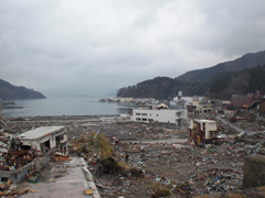
Damage in the town of Onagawa