□ On Wednesday, April 3, DGIST (President Kunwoo Lee) and the research team of Dabeeo Inc. (CEO Jooheum Park) announced the development of the world’s most performant neural network module for accurately extracting objects from aerial and satellite imagery. This technology is expected to have wide applications across various fields.
□ With recent advancement of deep learning techniques, a branch of artificial intelligence (AI), its application in the analysis of aerial and satellite imagery has become increasingly prevalent. However, existing models, being optimized for specific objects, had limitations in recognizing others. Additionally, these models often fail to reflect the morphological characteristics of objects, thereby leading to inaccurate results.
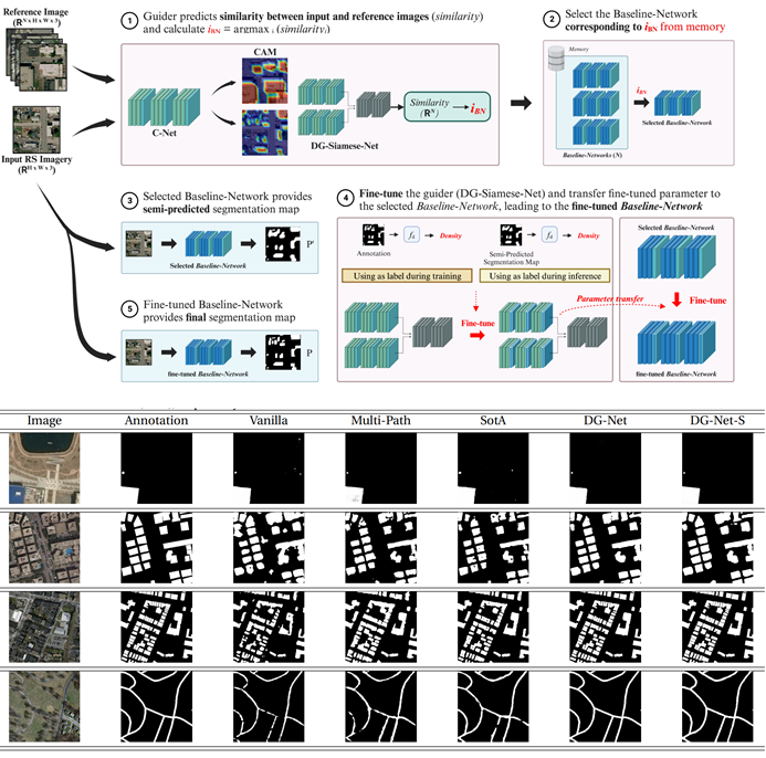
□ To address these issues, Professor Jaeyoun Hwang’s research team developed “DG-Net,” a neural network that provides far more accurate results than existing models and is applicable across a wide range of fields. DG-Net is an innovative artificial neural network that employs a test-time adaptive learning method, optimized for input images, to recognize object density and execute detailed segmentation. DG-Net has exhibited superior performance in various object segmentation tasks within aerial and satellite imagery, notably achieving exceptional accuracy in geographic spatial object segmentation, marking the highest performance compared to existing models.
□ The innovative AI neural network developed by the research team is expected to not only improve the accuracy of geographic spatial object segmentation but also to be applicable in various application fields, such as environmental monitoring, urban planning, agriculture, and disaster management. It is anticipated to become an innovative solution in the remote sensing field for object segmentation using aerial or satellite imagery.
□ Professor Jaeyoun Hwang from DGIST’s Department of Electrical and Computer Engineering stated, “The neural network developed through this research is a new neural network capable of extracting target objects from aerial and satellite images with high accuracy. Further advancements in related technology could see it applied in numerous fields, such as autonomous vehicles, defense, and medical imaging, thereby positively impacting the AI sector.”
□ This research was conducted with support of the “Defense Innovation Company 100 Dedicated R&D Support Project” through industry-academic cooperation with Dabeeo Inc. Additionally, the research results were published in the top-tier remote sensing journal, “IEEE Transactions on Geoscience and Remote Sensing (Impact Factor: 8.2)” on March 20, 2024.
- Ccorresponding Author E-mail Address : [email protected]