
The rising number of typhoons and incidents of heavy rain across Japan has meant an increase in the occurrence of landslides. In 2018 alone, Japan recorded a total of 3459 landslides.
Landslides cause extensive destruction to property and the economy as well as tragically result in the loss of life.
Now, a research team has developed a new mapping method that helps identify landslide disaster risks and predict their damage with high accuracy.
Associate Professor Shuji Moriguchi from Tohoku University's International Research Institute of Disaster Science (IRIDeS), who led the study, says the development is crucial for disaster risk reduction.
"The new method can accurately assess landslide disaster risks across a wide area with high resolution. If put to practical use, it will contribute to a highly accurate evaluation and real time prediction of landslide risks."
Landslides happen when rainwater infiltrates a slope over time, resulting in the stability of that slope decreasing until it gives way. The research team generated a model capable of analyzing this process and predicting unstable slopes in real-time. It was based on a Green-Ampt infiltration equation and an infinite slope stability model.
The model also took advantage of Geographic Information System (GIS) software. GIS allows for the analysis of spatial and geographic data and for that data to be visually represented using maps. Crucially, these maps can be generated across a wide area.
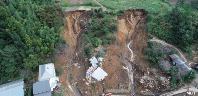
Moriguchi and his team tested their new system on Marumori, a town in southern Miyagi prefecture that was ravaged by landslides during Typhoon Hagibis in October 2019. Their numerical simulations aligned closely to the actual damage, indicating that the model can be applied to real landslides.
Contact:
Shuji Moriguchi
International Research Institute of Disaster Science, Tohoku University
Email: [email protected]
Website: https://irides.tohoku.ac.jp/eng/organization/moriguchi_shuji.html