
This image illustrates the colorimetric data of discolored seawater in four directions (north, east, south, and west) around Nishinoshima Island in 2020. The study investigated the color characteristics of the water to validate if the data obtained by SGLI accurately captures the actual conditions of the discolored seawater. It detected significant fluctuations in the distribution of chemicals in Nishinoshima Island, estimated from SGLI data, about one month even before the volcano became active.
A new study suggests sea discoloration data obtained from satellite images as a novel criterion in predicting if eruption looms for an underwater volcano.
There have been frequent eruptions of submarine volcanoes in recent years. The past two years alone recorded the explosions of Anak Krakatau in Indonesia, White Island in New Zealand, and Nishinoshima Island in Japan. Observing signs of volcanic unrest is crucial in providing life-saving information and ensuring that air and maritime travel are safe in the area.
Although predicting when a volcano will erupt can be difficult as each behaves differently, scientists are on the lookout for these telltale signs: heightened seismic activity, expansion of magma pools, increases in volcanic gas release, and temperature rises.
For submarine volcanoes, Yuji Sakuno, remote sensing specialist and associate professor at Hiroshima University’s Graduate School of Advanced Science and Engineering, proposed a new indicator — sea color.
The relationship between the chemical composition of discolored seawater and volcanic activity has been known for a long time. Still, there have been very few quantitative studies that used remote sensing to explore it. And among these few studies, only the reflectance pattern of discolored seawater has been analyzed.
“This is an extremely challenging research result for predicting volcanic disasters that have frequently occurred in various parts of the world in recent years using a new index called sea color,” Sakuno said.
“I was the first in the world to propose the relationship between the sea color information obtained from satellites and the chemical composition around submarine volcanoes.”
The findings of the study are published in the April 2021 issue of the journal Water.
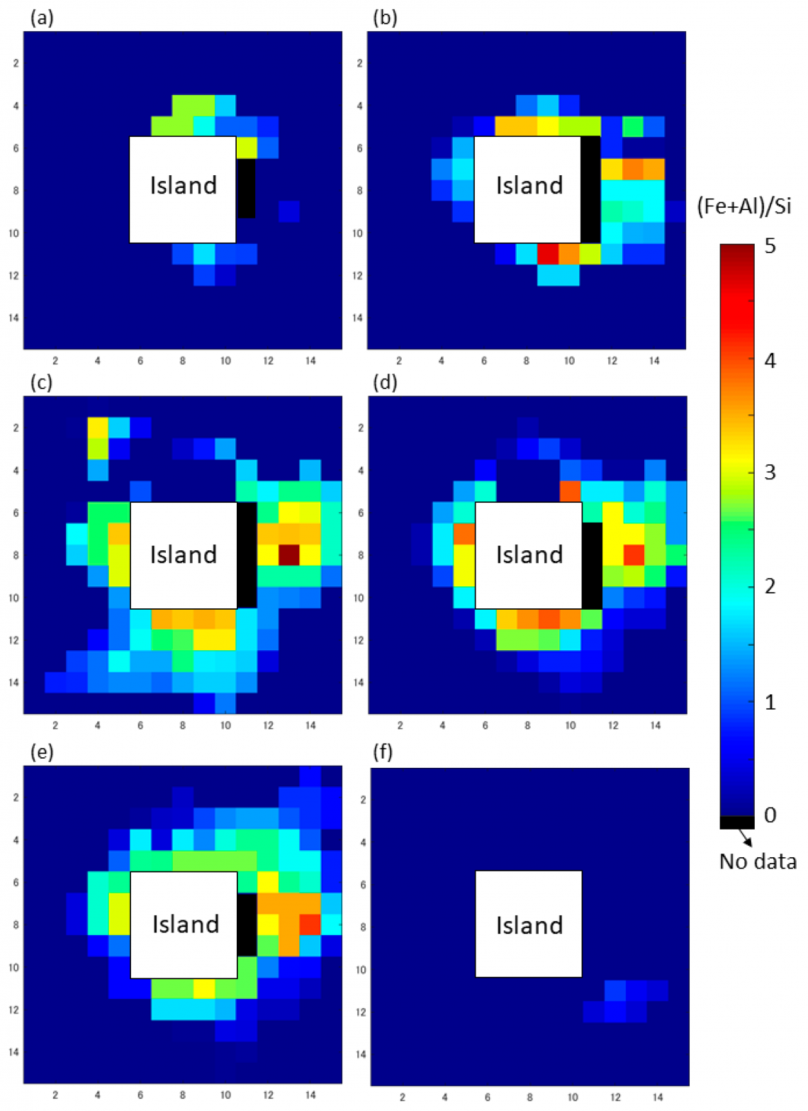
This photo shows a sample of the (Fe + Al)/Si distribution as a volcanic activity index from May 16 to June 25 around Nishinoshima Island: (a) May 16–23, 2020, (b) May 24–31, 2020, (c) June 1–8, 2020, (d) June 9–16, 2020, (e) June 17–24, 2020, (f) June 25–July 2, 2020. It is mapped by applying the equation ((Fe+Al)/Si)=45.4(x)−13.3 to the SGLI data. From this, it can be seen that during this period, the distribution on the northeastern part of the island rises, and then the discoloration gradually progresses to the sea area around the island, before it disappears. Nishinoshima Island is located approximately 1,000 km south of Tokyo, Japan. The original data used for this product have been supplied by JAXA’s JASMES (JAXA Satellite Monitoring for Environmental Studies).
Sakuno explained that volcanoes release chemicals depending on their activity, and these can change the color of the surrounding water. A higher proportion of iron can cause a yellow or brown discoloration, while increased aluminum or silicon can stain the water with white splotches.
One problem, however, is that sunlight can also play tricks on sea color. The study looked at how past research that chromatically analyzed hot spring water overcame this hurdle and fixed brightness issues. A relational model between seawater color and chemical composition was developed using the XYZ colorimetric system.
Sakuno examined images of Nishinoshima Island captured last year by Japan’s GCOM-C SGLI and Himawari-8 satellites. Himawari-8 was used to observe volcanic activity and GCOM-C SGLI to get sea color data. GCOM-C SGLI’s short observation cycle — it takes pictures of the ocean every 2-3 days — and high spatial resolution of 250 m makes it an ideal choice for monitoring.
Using the new indicator, Sakuno checked satellite data from January to December 2020 and was able to pick up signs of looming volcanic unrest in Nishinoshima Island approximately a month before it even started.
“In the future, I would like to establish a system that can predict volcanic eruptions with higher accuracy in cooperation with the Japan Aerospace Exploration Agency (JAXA), the Maritime Security Agency, which is monitoring submarine volcanoes, and related research,” he said.
###
About Hiroshima University
Since its foundation in 1949, Hiroshima University has striven to become one of the most prominent and comprehensive universities in Japan for the promotion and development of scholarship and education. Consisting of 12 schools for undergraduate level and 4 graduate schools, ranging from natural sciences to humanities and social sciences, the university has grown into one of the most distinguished comprehensive research universities in Japan. English website: https://www.hiroshima-u.ac.jp/en